Five Star Cooperative to deploy TerraClear AI mapping tools across more than 100,000 acres

Five Star Cooperative, an Iowa-based farmer-owned agricultural group, will work with ag-technology company TerraClear to deploy artificial intelligence-based field mapping tools across its grower network, starting in 2026.
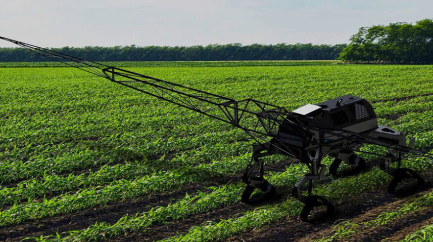
The rollout is expected to begin with rock mapping across about 10,000 acres, with a planned expansion into weed mapping covering up to 100,000 acres in spring 2027. The program will use TerraClear’s autonomous field scouting system, TerraScout, alongside drone-based data collection.
The companies did not disclose financial terms.
The partnership comes as U.S. farmers face continued pressure from elevated input costs and tighter margins, prompting increased interest in precision agriculture tools that can improve field-level decision-making.
TerraClear’s platform combines ground-based robotics with aerial imaging to generate detailed maps of field conditions. Its rock mapping system is designed to identify obstacles that can damage equipment or slow field operations. The company estimates the technology can reduce the time and cost associated with rock removal, though results may vary depending on field conditions.
The TerraScout system is designed to scan fields and identify weed presence by species and density, producing maps that can be used to guide targeted applications. The system processes data in the field and delivers results in near real time, allowing farmers to adjust operations without additional scouting passes.
The output can be integrated with existing farm equipment, including sprayers, to support more precise application of crop inputs. This approach may help reduce overall chemical use, depending on how growers implement the data.
To support deployment at scale, TerraClear plans to use a combination of autonomous scouts and drones to collect field data during the growing season.
Five Star Cooperative operates nearly 20 retail locations across Iowa and Minnesota, providing agronomy, grain marketing, livestock feed and fuel services. The addition of mapping tools is intended to help the cooperative members manage field operations more efficiently and better allocate inputs.
Enjoyed this story?
Every Monday, our subscribers get their hands on a digest of the most trending agriculture news. You can join them too!


Discussion0 comments