Amaggi will utilise satellite images for crops analysis


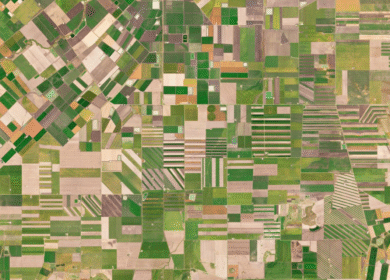
The Brazilian agricultural company Amaggi has signed a cooperation agreement with one of the Western satellite imagery suppliers. As follows from the agreement, Amaggi will daily receive and process information from satellites about the state of its fields to analyze crops and forecast yields.
Based on satellite images, Amaggi will analyze the results of fieldwork over the past years and will develop strategy for the cultivation of future crops. It will create a data cloud with archived and current images, integrating them into the corporate digital platform.
Amaggi is engaged in the cultivation of cotton, soybeans and cereals. Satellite images will be used primarily to monitor its cotton fields, which cover an area of 154 thousand hectares, and then to control the crops of other plants.
Enjoyed this story?
Every Monday, our subscribers get their hands on a digest of the most trending agriculture news. You can join them too!


Discussion0 comments